Last year over quarantine our employees knocked out a lot of projects. One project that the company accomplished was finally finishing the whitewater guidebooks we had been working on for the Forks, Upper and Lower Kern. Which was a great accomplishment, as we had started writing it back in 2017. (Turns out there was a lot of material to get through.)
Anyway, here’s the update as we approach the one year mark: We got it online in March and then didn’t look at the data until the Fall as we were busy running rafting trips on the Lower Kern. And when we did, it was pretty remarkable: Our Google Map files had been downloaded ~19,000 times. Our guidebooks were popular, no doubt. We don’t know exactly the user breakdown of that 19,000 but it clearly isn’t just private boaters, as that is far more than we see (at least as far as I know) that paddle on the Kern over the season. Likely it is broken out between private boaters, commercial guests on rafting trips, and non-rafters looking for river data.
From that success, we decided to expand our reach beyond the Kern River and map other rivers and creeks on a new website, GoRafting.com Today our database is quite a bit larger than our three Kern sections, and is expanding each week with new rivers and creeks.
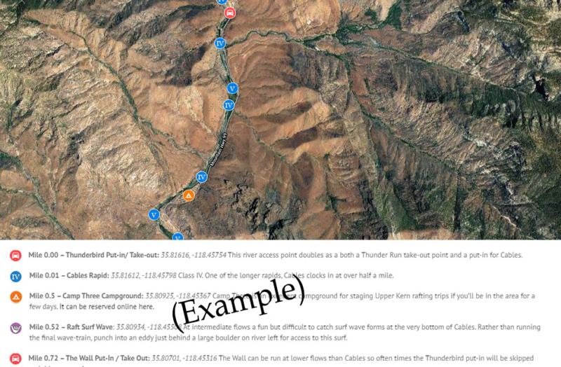
The Forks of the Kern guidebook can be found here.
The Upper Kern river guidebook can be found here.
The Lower Kern river guidebook can be found here.
We’re excited to see what 2021 brings with the project and if it requires some of us to explore new rivers, then we’re up for the task 🙂